The evening showers and storms are ending, with less storm coverage on Thursday!
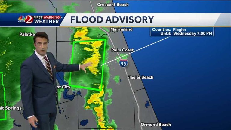
in some parts. East is good. Yes. center and west. Not so much. Exactly. Right where you are. Emphasis on the sun. Yes. Now let me take you out. Back to the coast there. Uh, Daytona is in good shape, but there's some cloud showers and storms starting to move over there. We'll show you this on the radar soon. Note the temperatures now to the north and west of town. Wildwood's arrival was 71 years old. Let us take a look at the live radar for you. Now. Good rain cover is developing across central and eastern Marion County. We do have flood warnings in place there which are still in force. You can see that the eastern outflow boundary is now closer to the east. The breeze is just colliding there, but we're not seeing any increase in showers and storms just yet. Uh, the heavy rain in Flagler County is tapering off, but light to moderate rain will try to return here in a short time. You can see 2 to 3 inches of rain in these flood warning areas west of Salt Spring and in rural areas of northern and northwest Flagler County. Rainfall amounts in excess of 2 to 3 inches north of 100 meters and northwest of Bennell. Now let's take a look. There are several hail cores here. Still north and west of I-4. There is a small band of storms trying to recover toward Daytona Beach and Port Orange. We will continue to keep you focused on the two news stories at six o'clock. We just had a collision and now you're starting to see a few showers develop east of Sanford east of Deltona. We'll have to wait and see if more wind develops towards Cleota and Bithlo, and over the next half hour you can see the breeze moving through east Orlando, through Avalon Park and now right here in Wedgefield, Moving toward BITHLO here, we have a couple of showers and storms developing along the Florida Turnpike. The breeze collided with it. Rainfall is likely to increase slightly over the next half hour today. Silver Spring 2.44 inches of rain. Burbank, Summerfield and the Villages are all getting very, very good rain conditions. There were a few showers and storms in the metropolitan area around seven, seven, thirty. After that, we look at the setup for Thursday and Friday. The Bay Area has higher pressure and is a little dry, not dry, but a little dry Thursday. However, as Friday approaches, the storm is returning. He will be big news on Thursday and Friday. Coastal communities, low 90s inland communities 94, 95, 96, maybe even 97. Take a look at these. The coming weekend feels like the temperatures are going to be very high. 103 to approximately 108 12 hour forecast. Now launching DAYTONA BEACH low top 90's. There. We'll take you into tomorrow afternoon. So, have some fun in the sun. But be aware that the storms there will develop around mid-afternoon and watch the rip currents there. Moderate risk of rip currents. OK A busy weekend begins on Saturday. More moisture is on the way as Sunday approaches. The tropical storm will arrive Sunday evening and Monday's weekend storm reports. Now, we have to increase it a little bit, to about 70%. The wave is coming. When you look at the water vapor pathways out there, the structures in southern Florida will be there Sunday night. Then to Monday. So we will continue to monitor this situation. We will introduce you to other areas of the tropics at 6:00. OK Get it all organized for you. Look at the 50% chance of rain tomorrow. It was as high as 60% on Friday. Even higher as we head into weekend coverage
The evening showers and storms are ending, with less storm coverage on Thursday!
Chief Meteorologist Tony Mainolfi has released the latest weather forecast for Central Florida. Radar Hurricane Severe Weather Warning Map Room
Chief Meteorologist Tony Mainolfi has released the latest weather forecast for Central Florida.
The evening showers and storms are ending, with less storm coverage on Thursday!

