go through: Dr. Samantha Ferrett
What are equatorial waves and why do we care about them?
Atmospheric equatorial waves are confined within the equator and move, or propagate, along the equator. Equatorial waves cause changes in pressure, temperature and wind. Each wave type has a different structure. Figure 1 shows an idealized example of a wave-type structure (called a Kelvin wave). In this case, Kelvin waves can either increase zonal winds or decrease zonal winds. Between these two states it is possible to increase the convergence of zonal winds or to increase the divergence of zonal winds. The wave propagates eastward, so a given area may experience increasing easterly winds, then weakening zonal convergence (wind direction away from a specific point, as shown by the red shading in Figure 1), then weakening easterly winds, and so on as the wave forms propagates along the equator. These changes in local atmospheric circulation can have an impact on the weather in the area where the wave propagates.

Idealized structure of Kelvin waves. Arrows indicate horizontal wind anomalies; colored outlines show where abnormal winds converge (blue) and diverge (red).
In this article I focus on the influence of equatorial waves on rainfall in Southeast Asia, highlighting some of the work done by the University of Reading on the Equatorial Waves and FORSEA programmes, funded by the Weather and Climate Science Service Southeast Asia Partner Program (WCSSP). Southeast Asia experiences unpredictable extreme weather, such as heavy rainfall that causes floods and landslides. Given their location on and around the equator, many areas of Southeast Asia are highly susceptible to modulation of local circulation by equatorial waves.
What is the relationship between equatorial waves and heavy rainfall in Southeast Asia?
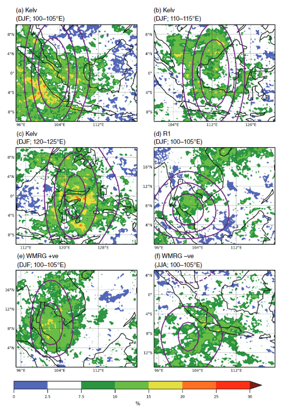
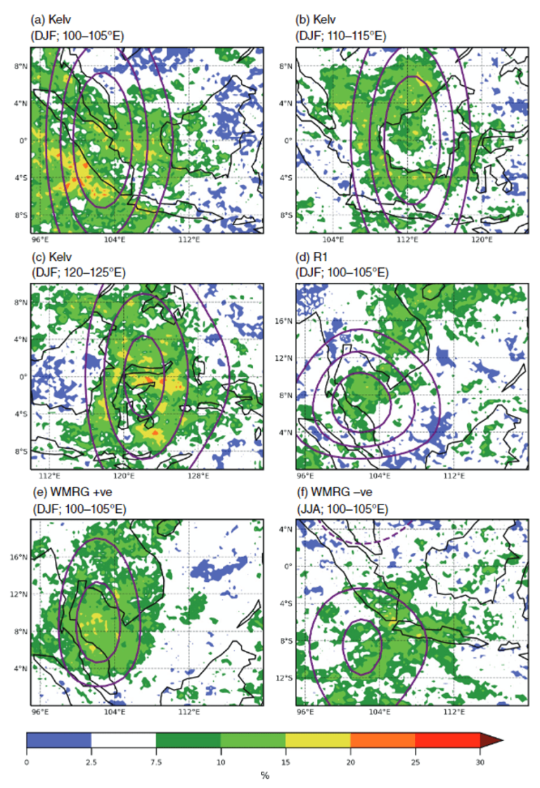
FORSEA and related projects develop a method to identify equatorial waves in real-world data and predictions Number(Yang et al., 2021)Number Can be used to examine the relationship between equatorial waves and heavy rainfall. Figure 2 shows the correlation between equatorial wave occurrence and the probability of heavy rainfall. Each panel shows a specific part of the wave that occurs over a specific area during a specific season. For example, panel a) shows changes in the probability of heavy rainfall when Kelvin wave convergence occurs in Sumatra during Northern Hemisphere winter (DJF). Yellow shading indicates about three times the likelihood of heavy rainfall, orange shading four times and red five times. The purple line shows where the winds associated with Kelvin waves converge. It is clear that there is a link between Kelvin wave wind convergence and the increase in heavy rainfall in Sumatra during DJF, especially in coastal areas.
There are many other areas where increased rainfall is associated with the occurrence of equatorial waves. Another wave type is shown in Figure 2, panel d. Unlike a Kelvin wave, this wave propagates westward and is defined by clockwise and counterclockwise circulation on either side of the equator. The solid purple line in this panel represents this counterclockwise cycle. This may be related to phenomena such as tropical storms. When a counterclockwise circulation (or “positive vortex”) associated with this wave appears over Peninsular Malaysia, the likelihood of heavy rainfall in the region increases again. Other panels in Figure 2 demonstrate several other scenarios. For more details, readers can find the full study published in QJRMS Number(Ferret et al., 2020)Number.

Figure taken from Ferrett et al. (2020). On days with strong wave activity in the lower atmosphere (850hPa), heavy rainfall may occur. The cases shown are (a) Kelvin wave wind convergence at DJF 100–105°E, (b) Kelvin wave at DJF 110–115°E, (c) Kelvin wave at DJF 120–125°E, (d) R1 wave at DJF 100-105°E, (e) westward moving mixed Rossby gravity (WMRG) wave convergence in DJF at 100-105°E in the Northern Hemisphere, (f) 100-100°E in the Southern Hemisphere The WMRG wave converges at 105° east longitude during JJA. Values of 5% and white shading indicate no differences from the climatology. The lines show the mean convergence (Kelvin and WMRG) or vorticity (R1) over these days at intervals of 5 and 1*10−7s−1, respectively. The solid purple line represents convergent/positive vorticity (a measure of counterclockwise circulation), and the dashed purple line represents divergent/negative vorticity.
Why does this work?
While this is all interesting, one might ask, “What's the point of this besides interest?”. Well, as I mentioned in the introduction, rainfall in Southeast Asia is very difficult to predict with our current forecasting models. However, equatorial waves can sometimes be predicted more accurately than the associated rainfall. This means we can use predictions of equatorial waves and our knowledge of the link between equatorial waves and the likelihood of heavy rainfall to create what we call “hybrid dynamic statistical forecasts” of rainfall. In the hybrid forecast, we use only forecasts of wave activity, not rainfall, to determine the likelihood of heavy rainfall. This type of forecast is superior to rainfall probability forecasts obtained directly from the model Number(Ferrett et al., 2023; Wolf et al., 2023)Number. In addition, combining the effects of multiple waves into one hybrid forecast further improves the skill of hybrid forecasts.
There is still much to learn about how waves and other patterns of change interact on different time scales, and what this means for heavy rainfall and other extreme weather events. The ongoing work in our new project FORWARDS aims to address these issues.
refer to
NumberNumberFerrett, S., Methven, J., Woolnough, SJ, Yang, GY, Holloway, CE, & Wolf, G. (2023). Hybrid statistical prediction of rainfall risk in Southeast Asia relying on equatorial waves. monthly weather review, 151(8), 2139–2152. https://doi.org/10.1175/MWR-D-22-0300.1
NumberFerrett, S., Yang, G., Woolnough, SJ, Methven, J., Hodges, K., & Holloway, CE (2020). Linking extreme precipitation in Southeast Asia to equatorial waves. Quarterly Journal of the Royal Meteorological Society, 146(727), 665–684. https://doi.org/10.1002/qj.3699
NumberWolf, G., Ferrett, S., Methven, J., Frame, THA, Holloway, CE, Martinez-Alvarado, O., & Woolnough, SJ (2023). Comparison of extreme precipitation probability forecasts for global and allowed convection ensembles with a hybrid statistical dynamic approach based on equatorial wave information. Quarterly Journal of the Royal Meteorological Society. https://doi.org/10.1002/QJ.4627
NumberYang, GY, Ferrett, S., Woolnough, S., Methven, J., & Holloway, C. (2021). Instant identification of equatorial waves and evaluation of waves in global forecasts. Meteorology and Forecasting, 36(1), 171-193. https://doi.org/10.1175/WAF-D-20-0144.1
