Weekend forecast:
There is a 30% chance of storms on Friday. There are some storms moving in this morning, however, we may see another round of scattered storms by this afternoon. These storms can bring frequent lightning strikes and torrential downpours! Temperatures climbed into the 80s and 90s due to clouds and rain.
The front will stall:
The front is expected to stall over Southeast Texas, with rain chances increasing Friday and continuing into the weekend. I'm not canceling any plans for this weekend, but I know you need to check your radar before you go.
Heavy rain is likely next week:
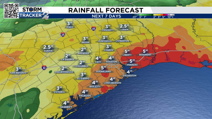
Once we get into next week, we're going to see a pretty stormy pattern for most of the week. A second cold front will move into the state and bring more rounds of heavy rain.
This front will also stall/hover for most of the week and allow smaller disturbances to bring multiple waves of rain to the area throughout the week. Rainfall totals could increase by 4-5 inches over the next 6-7 days.
Track the tropics:
There is no tropical activity in the Gulf, Caribbean Sea or Atlantic Ocean. Saharan dust is severe across much of the tropical Atlantic, making things very quiet.
Another factor keeping the tropics quiet is the huge clouds of Saharan dust, which help dampen the development of tropical waves at this time.
10-day forecast:
We may get some downpours, with heavy rain falling on and off from Friday into Wednesday. This rainfall may cause street flooding. Increased rainfall means cooler than normal temperatures.
Copyright 2024 KPRC Click2Houston – All rights reserved.
