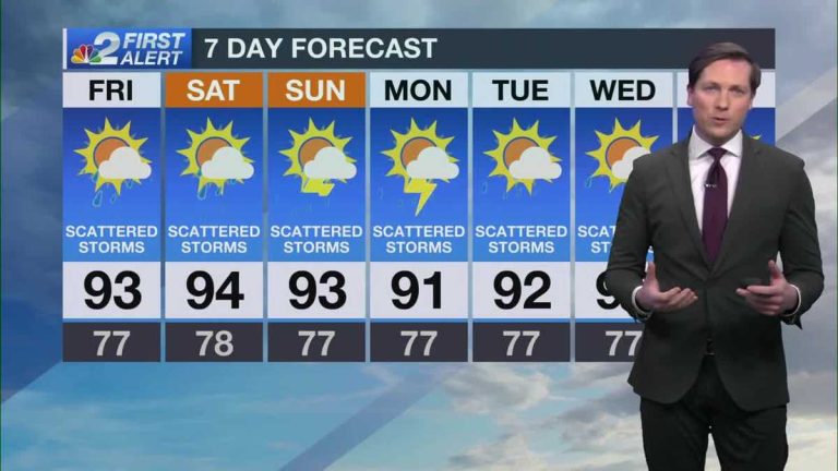
Scattered storms are expected Thursday night and Friday
Winds will be lighter on Thursday, so slow moving winds are expected as showers and thunderstorms form.
Especially here, especially this time of year, on a day like today, showers and thunderstorms pop up in our area, thunderstorms that aren't severe yet but can produce a lot of lightning, especially east of the interstate. 75.The storm is over. The Fort Myers area is currently seeing the heaviest rainfall just north of Forum just north of Colonial Avenue, and as you can see over Tyson on the west side of Buckingham, there have been six cloud-to-ground lightning strikes in the past 15 minutes. There are also some smaller showers near SUNCOAST Estates and between River Hall and Alva along Palm Beach Boulevard in northern Lee County, where you'll have your radar on for an hour. You'll find that the showers and thunderstorms here are moving very quickly, but they're trying to move north of the far northern layer in Lee County. Further showers and thunderstorms are possible in other parts of the area over the next half hour. You can see how much thunderstorms are currently affecting Glades, Hendry and Collier counties. Currently located on Big Bend and Interstate 75 between Golden Gate and Naples. There's a pretty big thunderstorm going on, and as you can see going off the radar for the past hour, there's just no movement. Also, it would be better to call it essentially stationary because we are talking about this poor guy who got struck by lightning, and it wasn't raining very hard at that time, just a lightning strike in Bonita Spring, for the past 20 minutes North of here, right where the X is on the screen. But now the storm is about 12 miles away. As a result, it is not unheard of for lightning strikes, sometimes referred to as “bolts from the blue,” to fly up to 10 miles from a thunderstorm. We've seen an example of this over the past half hour or so. Just a reminder, especially if you have kids or grandkids at home, if they want to play outside, hold on until these thunderstorms calm down because they are very active here, especially inland. Located east of the interstate. Storm 75, the strongest storm currently in our area, is located in central Hendry County between Immokalee, Clewiston and LaBelle City, where it was last seen moving on radar in the past hour Not fast, but trying to go west and northwest. So we're going to be keeping a close eye on thunderstorm development this afternoon around the city of LaBelle and the northwest areas of Hendry County, but at this moment, there aren't a lot of thunderstorms happening in Charlotte and DeSoto counties. But please be patient, there is a very good chance of rain and storms in our community today. As you can see, activity is very active right now and there's a good chance we'll all see some showers or thunderstorms before the night is over. This risk will be with us for the rest of the day today. In terms of temperature, you know, when you get a heavy rain, you get a temporary cooling down. But otherwise the weather will stay mild and muggy, with temperatures falling back into the mid-80s by 7 tonight, and then we'll drop back into the low 80s. As soon as we get the weather forecast ahead of 9.10 we will tell you that tomorrow's forecast looks very similar to what we are experiencing now. So throughout Friday's forecast, it's mainly the afternoon and evening hours. We will be looking for scattered storms in the sea breeze. We don't expect any wind tomorrow. As a result, storms in the form may progress rather slowly. So, as you would expect, the latter half of tomorrow will see some slow moving scattered rainfall again. Now through the weekend and early next week, we expect scattered storms to continue. There's something else changing our direction as early as this weekend called a layer of Saharan air that will make the skies look pretty hazy this weekend
Scattered storms are expected Thursday night and Friday
Winds will be lighter on Thursday, so slow moving winds are expected as showers and thunderstorms form.
Steering winds will be lighter on Friday, so movement is expected to be slow on Friday as showers and thunderstorms develop. A massive push from the Saharan air layer is expected to begin moving toward South Florida this weekend. Although we often see lower storm coverage when the Saharan air layer is nearby, current forecast models don't have much of an impact on rainfall development over the next week. With that in mind, we'll have hazy sunshine Saturday into Tuesday with scattered storms each afternoon and evening. Temperatures will remain warm, with temperatures in the upper 90s to low 90s each day. Thankfully, things remain calm in the tropics, and by next weekend we don’t expect any developments in the basin that would cause concern in Florida.
Steering winds will be lighter on Friday, so movement is expected to be slow on Friday as showers and thunderstorms develop.
A scattered round of storms is possible across Southwest Florida Friday afternoon and evening.
A massive push from the Saharan air layer is expected to begin moving toward South Florida this weekend. Although we often see lower storm coverage when the Saharan air layer is nearby, current forecast models don't have much of an impact on rainfall development over the next week.
With that in mind, we'll have hazy sunshine Saturday into Tuesday with scattered storms each afternoon and evening. Temperatures will remain warm, with temperatures in the upper 90s to low 90s each day.
Thankfully, things remain calm in the tropics, and by next weekend we don’t expect any developments in the basin that would cause concern in Florida.

