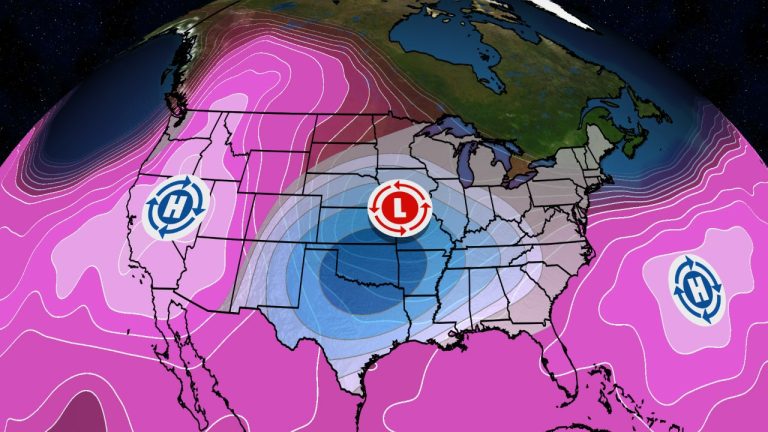

- The upcoming weather pattern looks a little strange for the height of summer.
- First, we'll get at least some relief from the sweltering heat across much of the South.
- Unfortunately, there are also thunderstorms most of the time.
- The worst heat in the nation will push into the Great Basin and Inland Northwest
The weather pattern will look strange over the next few days in late July, with record high temperatures heading into the Great Basin and Northwest as the heat eases in the Deep South.
We'll explain why this weird weather is happening later, but what initially caught our attention was the 6- to 10-day temperature outlook released Tuesday by NOAA's Climate Prediction Center.
Today, it seems increasingly difficult to find any areas with cooler-than-average temperatures in the long-term outlook. In contrast, the NOAA-CPC forecast for the last week of July shows significantly cooler than average temperatures in the southern Plains. Meanwhile, the areas most likely to be hotter than normal are across the West, as far north as the Canadian border.
(To track weather data in your area in more detail, check out our detailed 15-minute weather forecast Advanced professional experience.)


The 6 to 10 Temperature Outlook for the week of July 22-26, released on Tuesday, July 16, 2024, shows the bizarre temperature contrasts for this time of year.
(NOAA/Climate Prediction Center)
“Relief from summer heat” in the south: Late July to early August is typically the hottest time of year in much of the South.
This is because cold fronts usually dissipate before reaching the south by mid-summer. Instead, expanding bubbles of high pressure called “heat domes” typically keep the South hot.
But this developing strange weather pattern is pushing a weak cold front further south.
This will bring down the hot weather of the past few weeks by a few degrees. Across much of the South, highs in the 80s will be more common than the 90s.
Moist air may also penetrate parts of the region over the next few days, particularly from Oklahoma to Kentucky and Tennessee. That could drop temperatures into the low 60s, allowing people in those areas to let their air conditioners rest for a few hours and maybe even open their windows to get some air, at least in the morning.
(map: US 10-day forecast highs, lows)


But there is a problem: This “not too hot” weather won't be accompanied by clear skies across much of the South.
The cold front mentioned earlier has stopped. While it won't be quite as hot, the still warm, moist air will fuel showers and thunderstorms across much of the South, especially from Texas to the Carolinas but also at times in the Plains states.
While it won't rain all the time, next week is expected to bring more showers and storms than the typical summer's isolated “splash and dash” brief soak. Increased cloud cover and spells of rain will also keep temperatures slightly cooler.
By late next week, more humid air, along with a greater chance of showers and storms, will flow north into the Midwest and Northeast.
(map: US 7-day weather forecast with rain)


Where does the heat go: So, if it's not too hot in the South, East, or Midwest, and it's the middle of summer, where is the heat?
Unfortunately, parts of the West are going to be in trouble again.
This weekend, triple-digit high temperatures will be felt not only in typical desert Southwest areas but also as far north as eastern Washington state.
Boise, Idaho, and Spokane, Washington, could hit new daily highs. Not to be ignored is the possibility of record high temperatures in heat-fatigued California and the Southwest, including Las Vegas. We don't expect the heat to be as extreme as the record-setting heat wave of a few weeks ago, but it will likely continue into at least the first half of next week.
(Further enhance your forecasts with our detailed hourly breakdown for the next 8 days – only available on our website Advanced professional experience.)


Why are there strange settings: In short, the mood in the Lower 48 is going to be somber next week.
The heat dome will intensify over the West and extend its sweltering tentacles into western Canada and Alaska.
Combined with the presence of the Bermuda High, this will create an area of low pressure over the central United States, allowing it to rotate there for several days.
As long as this feature remains, the swirling cold air aloft will also help trigger the showers and thunderstorms we mentioned earlier from the plains to the south. This will likely last for much of next week.


A strange upper level weather pattern is coming the week of July 22nd.
Jonathan Erdman is a senior meteorologist for Weather.com and has been covering national and international weather since 1996. He earned a bachelor's degree in physics from the University of Wisconsin-Madison and a master's degree in dual-polarization radar and lightning data from Colorado State University. Extreme and weird weather are his favorite topics. contact him X (formerly Twitter), Number of execution threads, Facebook and blue sky.
