
- It's been quiet in the Atlantic basin since Hurricane Beryl.
- This is partly due to a surge of dust-laden air from Africa's Sahara Desert.
- A more favorable environment is expected to emerge in early to mid-August.
- This is consistent with the typical hurricane intensification that begins in August.
The Atlantic hurricane season could become active again as early as early August after weeks of calm weather dominated by Saharan dust.
For now, the quiet will last longer. The National Hurricane Center predicts no tropical storms will develop anywhere in the Gulf of Mexico, Caribbean or Atlantic Ocean for at least the next seven days.
This follows three named storms from mid-June to early July, one of which was early-season record-breaking Hurricane Beryl.
One reason for the recent calm in the tropics is a massive flow of dust from the African Sahara desert moving across the Atlantic basin, called the Saharan Air Layer (SAL). These SALs often inhibit development potential early in the hurricane season.
(To track weather data in your area in more detail, check out our detailed 15-minute weather forecast Advanced professional experience.)


Saharan dust analysis
(The areas in the lighter tan outline show areas in the atmosphere where dust is more concentrated, in this case originating from Africa's Sahara Desert. Satellite-detected clouds are also shown.)
But change is just around the corner: Computer models predict a reversal of this oppressive tropical environment.
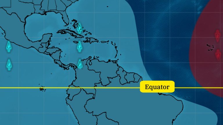
Specifically, models suggest that the Madden-Julian Oscillation (MJO) could turn the tropical Atlantic into an environment more conducive to tropical storms and hurricanes.
The MJO is basically a large area of increased cloud cover and rainfall that moves eastward from the Indian Ocean near the Earth's equator every 30 to 60 days.
It has branches of ascending and descending air. Where there is massive air rise, it is more conducive to the formation of thunderstorms, an essential component of tropical storms and hurricanes. This rising branch also reduces wind shear, which is also generally unfavorable to tropical development.
Computer models suggest this updraft will reach much of the tropical Atlantic basin sometime in early August. This could end areas of the tropical Atlantic that are currently dormant since Beryl.


The CFS model predicts potential patterns for rising (blue) and sinking (red) movement beginning in the week of August 5, 2024.
August usually accelerates. This long-term forecast is consistent with how a typical hurricane season evolves.
Activity in the Atlantic basin typically increases rapidly starting around mid-August as ocean warming approaches its seasonal peak, hostile wind shear reaches annual lows, and Saharan air surges begin to weaken.
By the way, there has been some lull in late July data since 1995, according to NC State Ph.D. Candidate Cameron Masiello.
(Further enhance your forecasts with our detailed hourly breakdown for the next 8 days – only available on our website Advanced professional experience.)
There remains a potentially dangerous season ahead. Many of the same ingredients that have concerned meteorologists since the spring are still present.
Ocean warmth remains at record levels for this time of year in a swath of the Atlantic basin from Africa to the western Caribbean, where many tropical storms and hurricanes form. Late September or October is more typical. If all other factors are equal, deeper, warmer water can fuel stronger hurricanes.


Current ocean heat content
(This map shows not only areas of warm water but also areas of warm, deep water, a component that drives developing and active tropical cyclones.)
Now prepare: About 92 percent of hurricane season activity, as measured by the ACE index, occurs between August and the end of hurricane season, said Phil Klotzbach, a tropical scientist at Colorado State University.
In a typical season, 12 storms and 7 hurricanes form in the Atlantic basin after July 31.
So take advantage of this quiet opportunity to make sure your hurricane plan is ready. This includes finding out if you are in an evacuation area, where you would go if asked to evacuate, and how to safely operate your generator in the event of a power outage.


More information about Weather.COM:
– The strongest hurricane in the U.S. is a tropical storm three days later
– The deadliest of recent U.S. tropical storms and hurricanes isn't the wind
– What does the prediction cone really mean?
Jonathan Erdman is a senior meteorologist for Weather.com and has been covering national and international weather since 1996. He earned a bachelor's degree in physics from the University of Wisconsin-Madison and a master's degree in dual-polarization radar and lightning data from Colorado State University. Extreme and weird weather are his favorite topics. contact him X (formerly Twitter), Number of execution threads, Facebook and blue sky.
