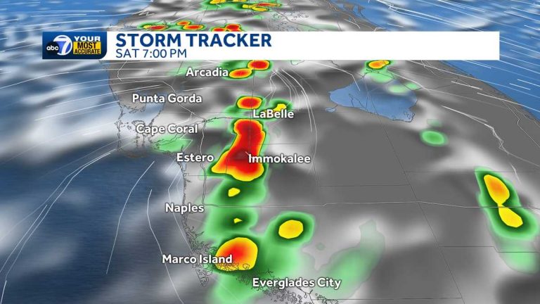
Another round of storms hits Southwest Florida on Saturday
Southwest Florida will continue to experience typical summer weather today. Highs will be in the mid to lower 90s and “feel like” numbers will be in the triple digits. Although we will start the day with sunny weather, another round of storms will develop as the sea breeze picks up in the afternoon. Easterly winds will bring ocean breezes to our side of the state, causing a chance of rain across the region. The first storm of the day will begin to develop after 3pm, with rain chances peaking between 6pm and 8pm before tapering off thereafter. Several storms will be severe, including heavy rain, frequent cloud-to-ground lightning and brief gusty winds. Sunday will bring more typical rainy season weather, with a dry morning followed by scattered storms in the afternoon, with highs reaching 90 degrees. Tracking the Tropics: The National Hurricane Center is monitoring a disturbance in the eastern Atlantic that will move west-northwest toward the northern Caribbean next week. It has a low chance of developing into a tropical depression and could approach Florida by next weekend. While it's too early to tell if or when this will have any impact locally, we'll be watching closely so stay tuned for updates.
Classic summer weather will continue today in Southwest Florida.
Temperatures this morning are slightly above average, rising from the mid-70s at sunrise to the mid-80s by lunchtime. Highs will be in the mid to lower 90s and “feel like” numbers will be in the triple digits.
While we will start the day with sunny weather, another round of storms will develop as the sea breeze picks up in the afternoon. Easterly winds will bring ocean breezes to our side of the state, causing a chance of rain across the region. The first storm of the day will begin to develop after 3pm, with rain chances peaking between 6pm and 8pm before tapering off thereafter. Several storms will be severe, including heavy rain, frequent cloud-to-ground lightning and brief gusty winds.
Sunday will bring more typical rainy weather, with a dry morning followed by scattered storms in the afternoon, with highs reaching 90 degrees.
Track the tropics:
The National Hurricane Center is monitoring a disturbance in the eastern Atlantic Ocean that will move west-northwest toward the northern Caribbean Sea next week. It has a low chance of developing into a tropical depression and could approach Florida by next weekend. While it's too early to tell if or when this will have any impact on our local area, we'll be watching closely so stay tuned for updates.

