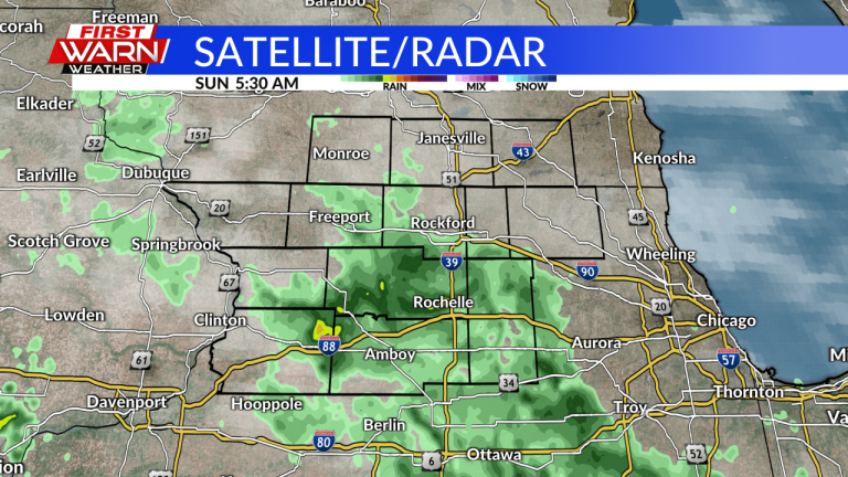
The chance for precipitation and thunderstorms will continue to increase over the next few days as an upper level wind ridge begins to move into the area. Currently, though, an upper level low pressure system is bringing increased humidity, moisture and precipitation to the state line this morning and afternoon.

Currently, there is widespread light rain in the southern counties of the state, and the rainfall will continue to move northeastward in the morning. While the rainfall won't be heavy, it will continue for at least a few hours in the morning until the clouds clear and sunshine emerges later in the morning.

However, depending on how the atmosphere recovers after the rain, some showers and thunderstorms may also develop this afternoon. Depending on the amount of sunlight we get in the morning, this can increase or decrease thunderstorm risk. At the moment, there isn't much instability or sunshine expected, but even so, some scattered thunderstorms are expected tonight with fast downpours and possibly gusty winds.
As evening approaches, instability will quickly diminish with the chance of thunderstorms.

By Monday morning, however, showers and thunderstorms were once again beginning to move into state lines. This is due to a small warm front moving northward in the morning, there is clearly some instability and some rumble of thunder cannot be ruled out tomorrow morning. This round is indeed more widespread with some heavy rain, so be on the lookout for widespread downpours and rumbles of thunder throughout the morning, especially during the morning travel time.

However, with skies expected to clear behind the line after Monday morning's game, instability will quickly increase Monday night. Sunlight is the main cause of the increase in unstable air, so the more sunshine, the more unstable the air is expected to be and the storms may be stronger. Currently, the Storm Prediction Center has us forecasting a 1 in 5 marginal risk of severe thunderstorms through Monday. This marginal risk applies to all hazards, but so far damaging wind gusts appear to be the biggest danger tomorrow.
Thunderstorms are expected to continue throughout the week as winds pick up aloft and high humidity and heat return across the Midwest.
