
A study by the USC Dornsife College of Letters, Arts and Sciences concluded that mercury concentrations and volumes are unusually high in Alaska's Yukon River watershed (see here).
Researchers believe these high values are caused by rapid melting of mercury-rich frozen permafrost along the Yukon River. They are convinced that the rapid melting is caused by dramatic increases in atmospheric temperatures caused by climate change.
As our planet continues to warm rapidly and unnaturally due to climate change, vast accumulations of frozen permafrost and other types of mercury-rich ice in the Arctic will melt, scientists on the study say.
Ultimately, continued releases of large amounts of mercury into the Arctic could irreversibly damage or destroy the Arctic's biological and physical environment. They called the impending disaster a “mercury bomb.”
The research has sparked a heated discussion about what we should do to avoid this looming environmental disaster. Here, we present evidence that the “mercury bomb” theory does not include all relevant data, observations, and information, raising questions about the theory's fundamental tenets.
1. This study was conducted in the Alaskan portion of the Yukon River. The river flows west through Alaska and empties into the Bering Sea. The problem is that the Bering Sea is the northern extent of the Pacific Ocean, not part of the Arctic Ocean. The suggestion that mercury in the Yukon River affects the entire Arctic is misleading.
2. The Yukon River and its surrounding watershed are approximately 2,900 miles long, 2 miles wide, and 5,800 cubic miles in area, making it the third largest river in the United States, behind the Missouri and Mississippi rivers. Study samples were collected in two small areas along the river and then used to determine mercury concentrations throughout the river. It is impossible to believe that two samples collected in this huge river basin can reflect the average or variation of mercury concentrations.
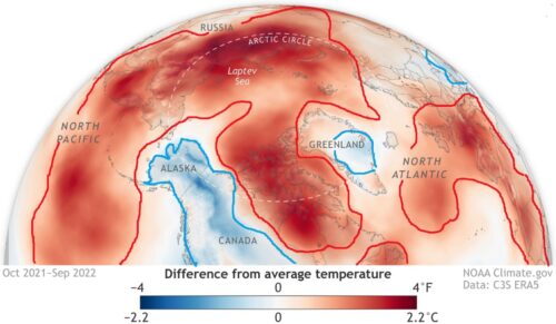
3. Due to climate change, atmospheric temperatures in the Arctic are extremely high. Data shows that’s not the case in Alaska. Between October 2021 and September 2022, atmospheric temperatures in Alaska were much lower than those above the Arctic Ocean (Figure 2 and here). In 2012, 1971 and 1975, its atmospheric temperature was below freezing.

4. The Alaskan portion of the Yukon River sits atop a large expanse of unusually hot bedrock/rock formations (see here ). Heat flow from these bedrocks is melting permafrost in rivers, not climate change.
5. There are approximately 20 mercury mines in the Yukon and Kuskokwim river basin areas (Figure 3). Mercury mining in the area began in 1884, so it is difficult to know the exact number or distribution of mines. However, one thing is for sure. Waste rock and sand from the mine were dumped near the Yukon and Kuskokwim territories. Most rivers may flood several times a month or a year.
The same is true for the Yukon and Kuskokwim River watershed areas. These floods altered mercury levels at previously sampled sites, making it almost impossible to believe that new samples could be used to establish reliable trends in mercury concentration or volume.
There is another question. Rivers with high flows and velocities are prone to constantly changing the position of sand laterally and downstream.
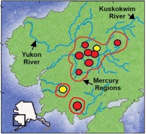

Figure 3 outlines in red areas of extremely high mercury concentrations in Alaska. However, within the region, there are small areas with extremely high mercury concentrations. These areas overlap with the location of mercury mines.
It makes sense for miners to choose small areas with extremely high mercury concentrations. As with many all-metal mines, areas of extremely high concentrations are caused by geological features such as faults, ancient rock formations, ancient lava upwellings and volcanic eruptions.
6. The large amounts of mercury released into the Arctic from terrestrial and marine geological features are significantly underestimated and not included in models assessing environmental problems currently attributed to human activities. Here are some examples of these geological features and their location in the Arctic.
7. Natural mercury concentrations in Greenland. “Unlike rivers in other parts of the world that are polluted by industrial activities, researchers believe Greenland's mercury comes from natural sources. If it comes from human contamination, the snow on top of the ice sheet should also be full of mercury—but previous research suggests it's relatively clean. Instead, scientists think the meltwater mercury may have been leached from the bedrock beneath the ice. “Mercury concentrations in meltwater rivers are at least an order of magnitude higher than those in ordinary rivers in the Arctic. The researchers say these concentrations are slightly diluted as they flow into the fjords, but are still higher than expected.” Even after mixing with salt water “Mercury levels in the fjords are still about an order of magnitude higher than those found in most open ocean waters.” (See here and here).
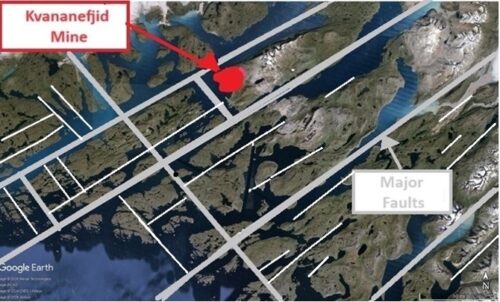
The Kvananefjid mine in Greenland (see here) is located along the pristine coast of southwestern Greenland (Figure 4, see here). Rocks in the area have been shown to be rich in mercury, radioactive uranium and phosphates. The mine is about to be mined as it is one of the largest deposits of radioactive uranium in the world. The area's indigenous tribes protested and the mine was banned. There is news that the mine is about to open.
As a geologist, I spent two summers working in open pit/surface mines, and I learned that open pit mining, which the new owners would be engaging in, was an extremely messy business. As a result, mercury and phosphorus from mined rock and reservoirs built to hold mine waste can leak into the ocean and bays, especially when mining operations end.
Currently, the mine operator is no longer responsible for maintaining the waste repository or other parts of the mine site. This greatly increases the likelihood that the waste repository or other parts of the mine site will malfunction and no longer prevent the flow of mercury into rivers and oceans. As evidence, you may remember the failure of Florida's phosphate mines (see here ).

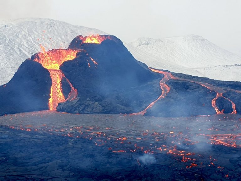
8. The eruption of Fagradalsfjall volcano in Iceland (Figure 1) spewed lava and gases, both of which contained mercury (see here). The amount of mercury released into the atmosphere and oceans from large, medium, and small terrestrial or marine volcanic eruptions is based on monitoring of a very small number of volcanoes. Therefore, calculating the accuracy of calculating the amount of mercury emitted by volcanic eruptions versus the amount emitted by humans is just guesswork.
Keep in mind that we mapped only 25% of the ocean floor using high-resolution equipment that can see smaller low-relief geological features. Multiple studies have proven that high-resolution mapping allows them to see 30-40% of small geological features.
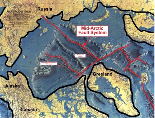
9. The Arctic Ocean floor is home to hydrothermal vents, volcanoes, and the vast 3,000-mile-long Central Arctic Rift System, an active, ever-changing continental rift. The fault system is currently very active and has and will generate thousands of small and medium-sized faults (Figure 5). Add all these seafloor geological features together, and there are at least 50,000 geological features, many of them in the Arctic Ocean and on land.

generalize
A study by the USC Dornsife College of Letters, Arts and Sciences concluded that mercury concentrations and volumes are high in Alaska's Yukon River basin.
They believe these high mercury values are the result of rising atmospheric temperatures due to climate change, which is causing large areas of frozen permafrost that contain large amounts of mercury to melt.
Their analysis did not include a wealth of relevant data, observations and information. Once included, the “mercury bomb” theory becomes invalid.
pass
James Edward Kamis is a retired geologist with 47 years of experience, holding a Bachelor of Science degree in geology from Northern Illinois University (1973) and a Master of Science degree in geology from Idaho State University (1976). Nearly five decades of research have led him to believe that geological forces significantly influence, or in some cases completely control, climate and climate-related events, as explained in detail on the Plate Climate Theory website. Kamis's new book, “Geological Influences on Climate,” is out now.
Author's Note
This article is not intended to castigate the many scientists involved in research at the USC Dornsife School of Letters, Arts & Sciences, nor to question their intentions.
