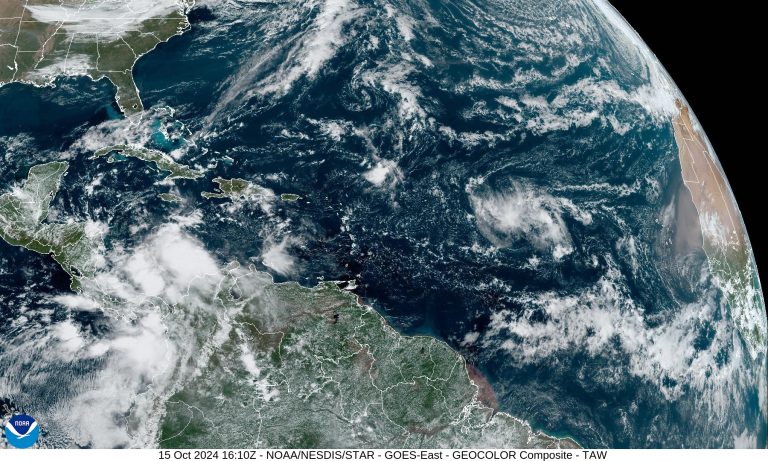
A disturbance identified as Invest AL94 is developing and moving toward an area east of the Antilles Arc with a high potential for cyclone formation, with a 30% chance of becoming Tropical Storm Nadine, and reaches the Gulf as a hurricane.
Right now its trajectory seems to be heading toward Puerto Rico and the northeastern part of the Dominican Republic, and if that's the case, Florida and the Caribbean unfortunately have to continue to be very concerned about the evolution of this riot because if it gets to that area, that area conditions will be affected. As predicted, the 2024 hurricane season will be very active.


The National Oceanic and Atmospheric Administration predicts that 17 to 25 tropical cyclones may form this year, including disturbances, depressions, storms and hurricanes. Of those, 8 to 13 have the potential to become tropical storms, with winds exceeding 39 mph, and some may reach hurricane status, with winds exceeding 74 mph. Likewise, it is expected that as many as seven of these hurricanes could reach Category 3 or higher, with wind speeds exceeding 110 mph, marking a particularly intense season.
As we said before, the displacement of the Intertropical Convergence Zone results in less disturbance from the African continent, where unusual flooding occurs. However, in the North Atlantic and Gulf of Mexico, the effects of a phenomenon known as the Atlantic Pool led to the intensification of hurricanes such as Belle, Helen, and Milton.
The Atlantic Pool is a large mass of warm water that is critical to the development of severe storms. This is due to a warm pool in the Gulf, aided by a slowdown in the meridional circulation of the Atlantic Oscillation.
However, this year's hurricane season is playing out a little differently, leading experts to believe it could extend beyond November 30, the date when hurricane season officially ends. This is due to a change in activity peaks, which traditionally occur around September 10, but this year the peak has shifted to October, with increased activity in the first half of October.
This shift in cyclone activity may be related to a variety of climate factors. One of these is the neutral phase of El Niño, whose positive phase typically suppresses Atlantic hurricane formation. But because it is in the neutral phase of transition to La Niña, it will not produce strong enough winds to weaken the Atlantic cyclone system. However, global warming is also affecting weather patterns around the world, changing the traditional dynamics of the hurricane season.
A clear example of the impact of the Atlantic Pool is the intensification of Hurricane Milton. Due to this phenomenon, it can rise from Category 2 to Category 5 in a few hours; a Category 3 hurricane that hit the southern part of Saratoga on the Florida Peninsula with wind speeds of 193 km/h, killing 23 people and causing more than 50 billion in damage dollars, causing massive damage, especially the number of tornadoes it produced, as well as the storm surge exceeding 10 feet.
Observed behavior during the 2024 hurricane season highlights the importance of remaining vigilant and prepared as changing climate properties and the different phases of ENSO, the Gulf of Mexico water quality pool, and the Atlantic Oscillation's Southern Circulation; ocean warming continues to indicate that hurricane season May become increasingly intense and unpredictable. As the season progresses, it is important to follow authorities' advice and monitor weather forecasts to reduce the potential impact of these powerful storms.
