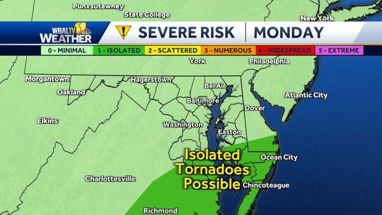
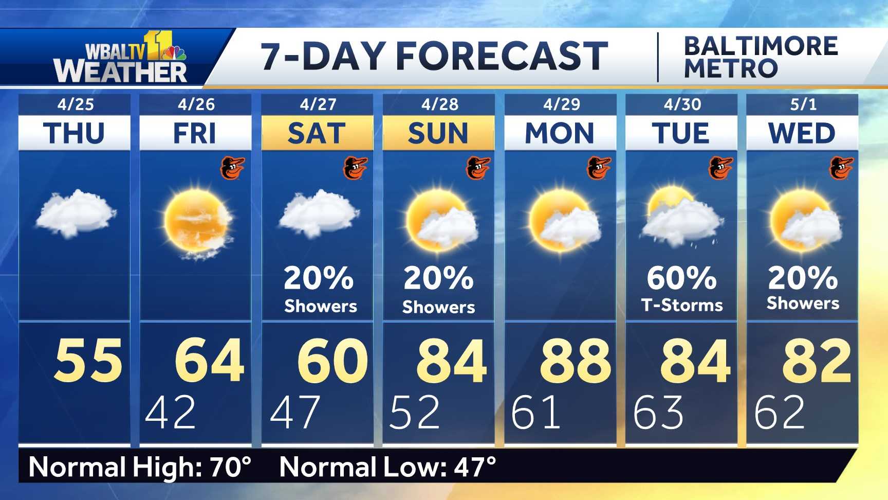
The time is now 445. The weather is dry but feels very humid. It's going to be a very muggy day with lots of clouds and eventually a chance of showers and thunderstorms. The temperatures are really just down to the low 70s right now, and it feels very humid outside, so when you get in your car, you're going to need air conditioning. There are a lot of clouds overhead and that will persist. Most of today. This keeps temperatures from being as high as yesterday. Much of Maryland is currently in a drought. But you can see this severe thunderstorm just forming in northwest Philadelphia, just sitting there. So, unfortunately, these communities may experience some flash flooding. We could also see some showers in West Virginia. So, in this weather pattern, they can be heavy and stay in place when a storm pops up. The atmosphere is currently at a standstill across the region and will slowly move northward over the next few days. There is also some instability in our north. So, all of this gives us a chance for multiple showers and storms over the next few days. They're scattered, but in terms of severe threats, they can be heavy, and we're mainly just seeing some downpours, but there's a little bit of a spin in the atmosphere today in the southern part of the state. Therefore, if thunderstorms occur in southern Maryland and the lower Eastern Shore, the risk of triggering tornadoes is at least minimal. So, when you are at even a small risk of a tornado during this weather situation, it is important to stay connected immediately and have a way to get severe weather warnings. You can do this directly through our WBAL app for the Baltimore area. Today we'll be looking for showers and thunderstorms primarily from midday to afternoon. So we're basically dry by 9:00 as we move into the 80s. Showers and storms are possible at any time today. Although it’s unlikely to be a full day. Therefore, FUTURECAST will show that by 10:00, showers will begin in Gaithersburg. By noon, though, they began moving into the Baltimore area. The southern part of the state is heavier. Then in the afternoon it will start to rain heavily in some places and then it will continue to drift across the area. Therefore, by 4:00, they may reach the northern suburbs in the rain. There may be some thunder and lightning. So if you hear thunder, you'll want to stay safely inside. If it has just rained in your neighborhood, you can go out with an umbrella. But heavy downpours continued into the night again in some areas. They have become more isolated overnight, but some light rain is still possible into the early hours of tomorrow. We take a break at noon. There will be a little sunshine tomorrow so Tuesday will be a hotter day. But we'll have to watch late into the night when thunderstorms start up again. Heavy rain is possible on Tuesday night in some places, so check our 7-day weather forecast. We've got some high impact weather today as there's a chance of showers and storms, which you'll want to avoid no matter where you're working. You plan to go beyond 83. Tomorrow will be a bit hotter as we see more sunshine during the day and then watch for showers. Thunderstorms will develop again Tuesday night and early. A few showers and storms remain through Wednesday. Showers and storms remain on Thursday. As we move toward our goals, we will break the pattern
Weather affecting thunderstorms and downpours on Monday
Meteorologist Ava Marie said Monday will be a disruptive weather day as heavy rain and possible severe thunderstorms will mostly occur at night. Closings/Delays | Weather Advisory | Radar | Forecast | Email Alerts | Send Us Your Photos | | Cloudy and humid most of the time, as temperatures won't be that hot in the low to mid 80s. The storm is expected to start with scattered showers in the afternoon before becoming stronger in the evening. Heavy rain is possible in some areas, so be aware of sudden downpours, especially when driving. Rain comes and goes, but can be heavy in places. The region needs rain and much of the state is in drought. Lightning is also possible. The southern Maryland/lower East Coast is at a marginal severe risk (Category 1 of 5) for tornadoes, with models showing rotation in the atmosphere. Rain continues into the evening with isolated showers and a greater chance of thunderstorms and will continue into Wednesday when temperatures start to return to normal. Ava is monitoring possible storms Tuesday night and Wednesday, with more impacts possible later in the week. Link: MDOT SHA Statewide Transportation Operations Response Map Download the WBAL-TV app now and turn on push alerts for severe weather warnings, listen to NOAA Weather Radio and watch WBAL-TV 11 when severe weather is imminent. @TTasselWBAL | @AvaWBAL | @TonyPannWBAL | @DalenciaWBAL | @alenaleewxWBAL-TV 11 Maryland Weather Radar App users click here to get the interactive radar. Impact Day. What this means: An impact day is when the weather may disrupt your normal daily schedule or routine. to electrical wires and other power transmission equipment. Baltimore Gas & Electric is asking all customers to report outages in any of the following ways: Online, at BGE.com BGE's free mobile app, available on the Apple Store or Google Play Text message to 69243 Call 877- 778 -2222 The latest outage information, including total numbers and general location, is available on the BGE.com power outage map. Please call BGE at 877-778-2222 to report downed power lines, outages and gas odors. : Use this form to upload a photo or video.Is a school, business or organization closed or delayed Radar: Track snow, sleet or freezing rain with WBAL-TV's interactive radar Roads: Check for collisions and backups with our interactive traffic map Winter: Guide: Snow Safety, Driving Hazards, power outages Tornado survival: 5 things you need to do now Hurricane preparation: How to prepare for hurricane season
Meteorologist Ava Marie said Monday would be a disruptive weather day with heavy rain and the possibility of severe thunderstorms in the evening.
|| Closures/Delays | Weather Advisory | Radar | Forecast | Email Alerts | Send Us Your Photos ||
It will be mostly cloudy and humid as temperatures won't be as hot as the mid-80s. The storm is expected to start with scattered showers in the afternoon before becoming stronger in the evening. Heavy rain is possible in some areas, so be aware of sudden downpours, especially when driving.
Scattered showers and thunderstorms will begin around midday and continue into the evening. Rain comes and goes, but can be heavy in places. The region needs rain and much of the state is in drought. Lightning is also possible.
The southern Maryland/lower East Coast is at a marginal severe risk (Category 1 of 5) for tornadoes, with models showing rotation in the atmosphere. Rain continues into the evening with isolated showers and a greater chance of thunderstorms and will continue into Wednesday when temperatures start to return to normal.
This content is imported from Twitter. You may be able to find the same content in another format, or you may be able to find more information, at their web site.
Temperatures will climb back into the 90s on Tuesday, but will feel much warmer due to the humidity. Ava is monitoring possible storms Tuesday night and Wednesday, with more impacts possible later in the week.
| association: MDOT SHA Statewide Traffic Operations Response Map
Download the WBAL-TV app now and Turn on push alerts For severe weather warnings, listen to NOAA Weather Radio and watch WBAL-TV 11 when severe weather is imminent.
@wbaltv11 | @TTasselWBAL | @AvaWBAL | @ TonypanWBAL | @dalenciaWBAL | @alenaleewx
WBAL-TV 11 Maryland Weather Radar
App users click here to view the interactive radar.
Maryland 7-day weather forecast
Alert Days and Impact Days
You may see the WBAL-TV 11 Weather Team highlighting warning or impact days in the forecast. what does that mean:
- An impact day is when the weather may disrupt your normal schedule or routine.
- Warning days are days when there is an extreme, severe and potentially life-threatening weather threat.
potential power outage
Storms can cause tree branches to snap down power lines and other power transmission equipment, causing power outages. Baltimore Gas & Electric is asking all customers to report outages in any of the following ways:
The latest outage information, including total numbers and general location, is available on the BGE.com power outage map.
As a reminder, never approach or touch downed overhead power lines, even if they do not appear to be live or sparking. Please call BGE at 877-778-2222 to report downed power lines, outages and gas smells.
Share your weather photos and videos
Show us your weather photos and videos and we may use them on 11 News or online!


