Weather: Impact Day: Storm Tuesday
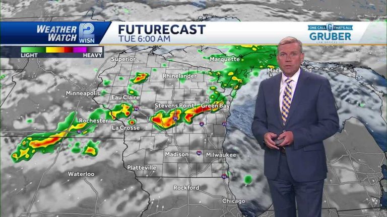
Well, today is our seventh dry day in a row in Milwaukee. Yes, the longest spell of dry weather since February. This is by far the best weather we’ve had all spring and summer. So that's great. Now we have to deal with one day of rain, but then we're back to where we were before. So this really isn't going to be long-term. as usual. We saw it was raining. That's a good thing. We do have thunderstorms to the north. They were moving slowly south. Now there are showers and thunderstorms not far away. That's not moving toward us. It will move southward as we advance through the night. But it won't be in a rush to get here. Thunderstorms are back again, with severe thunderstorm warnings in the distance for Minneapolis and St. Paul. Note how this collapsed overnight, which is not unusual at all. Uh, pretty typical 6:00 in the morning, still north of us. Then we'll see some scattered showers and some thunderstorms. It looks like we're unlikely to have bad weather here. There may be a few gusts and the wind will be a little stronger. There might be some hail damage, but it doesn't look like a big deal. We also get a lot of drying time. So the chance of rain is greater in the afternoon. There's still plenty of drying time. Get your umbrellas ready as we head into Wednesday. It started out cloudy, but by Wednesday it was at least sunny. But Wednesday looks dry again. How much rain did it rain? That's one thing we've seen from this. Very good downpour tomorrow. So if you're under one of those, that could be a problem. Well, love this camera shot from the top of the Bank of America building. Looking back at Summerfest, this weekend's Germanfest we are putting on an air and water show. There are a lot of different things going on here. And Harley Day. So be extra careful this week. You should always be careful, but there will be a lot of extra motorcycles coming into town. Blue sky and Waukesha 77 degrees 77 now on top of the Oconomowoc Bank Five Ninth Building. What a great night. Tomorrow is uncertain as we'll have to deal with some scattered showers and thunderstorms, outside, outside, outside, outside. There will be showers and storms on Tuesday. Tuesday and Wednesday will be muggy, then dry and comfortable, and then into next week we'll start to warm up with temperatures in the 80s to 83 degrees. Gets slimy, not so bad. Then it got sticky again. We're approaching this weekend. Take a quick look at this morning's sunrise because I want to show you the red sunrise. Oh yes, the smoke is back, thankfully it's already rising in the atmosphere. So get ready for a red sunset. Also, be prepared for temperatures to rise and the stickiness to start setting in. Oh, it looks like the heat will continue for a while. Partly sunny with a chance of thunderstorms in the afternoon. Today is a high impact day due to the storm. Again, don’t expect bad weather. Clearance on Wednesday, Thursday and Friday looking pretty good. The weekend is starting to heat up, but it's looking really dry for thousands of events in southeastern Wisconsin.
Weather: Impact Day: Storm Tuesday
Weather: Impact Day: Tuesday Storm Tonight: Pt. cloudy. Low: 65 Tuesday: Sun early. Showers and storms in the afternoon. Severe storms are unlikely. Height: 83
Weather: Impact Day: Storm Tuesday
Tonight: Pt. cloudy. Low: 65
Tuesday: The sun is early. Showers and storms in the afternoon. Severe storms are unlikely. Height: 83

