Storm impacts with flood risk
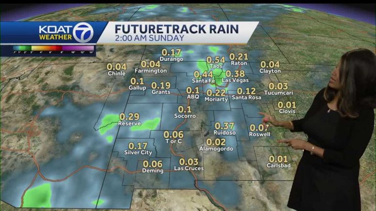
Oh wow. Well, it rained a little while we were out. All I know is what it was like when I was there. And you? Well, no, it was just a little humid and then the sun started to come out. No rain. We still have a chance of another rain. One cell that passed about an hour ago was very sparse. It's mainly hit the western half of town, but now we're starting to see more action on radar. This will continue to intensify as we head towards the sunset. A flash flood warning has been issued for Mora County. It's affecting parts of the Hermit Peak Burn Scar area in Calf Canyon, where temperatures are lingering until 530, and the wide view from the pictures shows a lot of showers and storms to our south and west in some areas. The flood warning will remain in place until around midnight tonight. This is from the National Weather Service, who believe that some flash flooding is still possible as we move into later tonight. For most of our quad cameras, the view from Rio Rancho to Santa Fe to Farmington was nice, with blue skies mixed with some clouds, but Ruidoso started to get a little darker and we could Seeing some heavier showers. The current temperature feels good. Most of us are in the upper 80s to the lower to mid 90s. The weather in the south is hot. It's currently 99 degrees in Las Cruces, but the impact pattern will continue in the Albuquerque metro until about 10 tonight. Please note that we have a 50% chance of rainfall. If you're heading out tonight, perhaps into the city, you'll definitely want to bring some rain gear with you in case there's a shower or storm in your direction. The potential is definitely there. We'll also see more showers Saturday afternoon and Saturday night, which will carry us into early Saturday morning. But I do have some good news for you about the second half of the weekend. By Sunday we are usually dry. We're going to bring back a lot of sunlight and even more heat. So as we step out into the cooler morning air, let's keep an eye on our forecast models. With most of us in the upper 50s, lower 60s, we will see temperatures really spike near noon and quickly move through the 80s and into the 90s. Scattered showers will start in the early afternoon for most of us, covering mainly the western half of the state, but the chance of scattered showers will become more widespread by tomorrow night as we move into Saturday night. But as I mentioned, Saturday night is when we clean up, we're going to be dry, and we're going to have a drier trend as we start next week. Let us take you through the forecast for your area. As I mentioned, we're actually going to see some excess rainfall. In some cases, certain locations are tomorrow. Much of the state will be affected by this rainfall. But then you can expect plenty of sunshine in the Four Corners area of Farmington and surrounding areas. It was a mild morning with temperatures approaching 60 degrees. Temperatures are comfortable in the low 90s. But note the growth trend in the mid-90s to upper 90s, which is now approaching 100 degrees. next week. Therefore, the hot weather of summer is definitely here to stay and come back. Silver City, you look good. You'll see some sunshine tomorrow morning, but clouds will quickly take over by lunchtime. This increases the chance of rain later in the day. Additionally, cloud cover will suppress some of the daytime warming, so temperatures won't reach the 90s over the next few days. Roswell will be back with triple digits by the middle of next week and even some dangerously high temperatures, we could hit 105 by Wednesday afternoon. That will continue as far as the scattered showers you see in Las Vegas, Red River, and Raton. But the pattern will be similar. Some broken cloud cover midday, showers and thunderstorms later in the day, then another hot, dry day. If you're planning on attending the Santa Fe Festival on the Plaza and you might see some sunshine over the weekend, be prepared for some hot weather in the middle of next week. Temperatures will be slightly above average in the metro tomorrow, but the outlook for the next seven days is looking pretty good. We'll spend today's Impact Day and then head to UPPE
Storm impacts with flood risk
Be sure to download the KOAT app to receive customized weather alerts. You can also watch the latest weather forecast on the app.
Be sure to download the KOAT app to receive customized weather alerts. You can also watch the latest weather forecast on the app.

