In a hurry? Here's everything you need to know about what's happening in the tropics (in less than a minute).
Based on the latest reports, the National Hurricane Center has increased the likelihood that the tropical wave will strengthen as it moves toward Florida and the United States.
If sustained winds reach 39 mph, it could become Tropical Storm Debbie, the fourth named storm of the 2024 Atlantic hurricane season.
➤ Track all active storms
NHC forecasters said there is a 60% chance the system will develop over the next seven days and a tropical depression could form later this week.
AccuWeather meteorologists said the system has the potential to become a tropical storm before approaching the United States in early August.
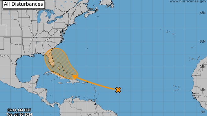
Although the colored areas may look like the hurricane center's “cone of concern,” the orange areas on the agency's Tropical Outlook map actually represent areas where tropical cyclones are likely to develop.
Tropical cyclone is a general term covering all tropical systems, including tropical depressions, tropical storms and hurricanes.
Here are the latest updates from the NHC's forecaster tracking system as of 8 a.m. July 30:

A large tropical wave centered hundreds of miles east of the Lesser Antilles is producing limited shower activity due to dry ambient air.
➤ Excessive rainfall is expected
Conditions in the warm waters of the southwest Atlantic are expected to become more favorable for development, with the potential for a tropical depression to form later this week when the system is located near the Greater Antilles or Bahamas.
Residents of the Greater Antilles, Bahamas, and southeastern United States should monitor the progress of this system.
- Chance of formation within 48 hours: Low, close to 0%.
- Chance of formation within 7 days: Moderate, 60%.
Storm tracker: Monitor tropical waves moving toward Florida

AccuWeather says there are several factors that influence whether a tropical wave intensifies and where it goes. Bottom line: Residents of the Caribbean and the United States should pay close attention and prepare.
The tropical wave is currently battling dry air and wind shear as it moves westward. Both help prevent tropical systems from developing or intensifying. That will change this weekend in August, which is typically the start of the busiest period of the Atlantic hurricane season.
“By the end of the week, the waves will move into an area of fairly low shear and good moisture, which could bring some organization and strengthening,” AccuWeather chief hurricane expert Alex DaSilva said.
Then there will be “ripples”. As the tropical wave “interacts with another wave in the atmosphere early this week,” the two may merge into an area of low pressure, AccuWeather said.
“Exactly how these two storms interact and where they re-form into a single storm could determine the future path this week around the Caribbean and perhaps beyond the United States,” AccuWeather forecasters said.
Two scenarios cited by AccuWeather that could impact the United States include:
- The U.S. East Coast will be more likely to be of concern if the storm moves north of the large Caribbean islands later this week
- If the storm moves only south of the big islands, the U.S. Gulf Coast could be more of a concern.
Another factor affecting the direction of the tropical wave is the high pressure system over the mid-Atlantic, which is currently moving the tropical wave westward. By the weekend and early next week, “wind direction should shift the tropics toward the northwest or north” near the United States, AccuWeather said.
“Everyone from the northern Caribbean to the Bahamas and from the U.S. Gulf Coast to the Carolinas will have to pay close attention to this tropical feature,” AccuWeather forecasters said.
What do the colored areas on the NOAA map mean?
Jamie Rohm, deputy director of the National Hurricane Center, said the striped areas on the Tropical Outlook map represent “areas where tropical cyclones, which could be tropical depressions, tropical storms or hurricanes, may form.”
The colors clearly show the likelihood of system development, with yellow being low, orange being medium and red being high.
The National Hurricane Center generally does not issue tropical warnings until a designated storm occurs, with one exception.
“If a system is close to land and has the potential to develop, the National Hurricane Center will not wait to issue an advisory, even if the system has not yet become a true storm. This gives residents time to prepare,” Rohm said.
Who might be affected?
It's too early to determine whether the tropical wave will have any impact on Florida or the United States, although wherever the tropical wave goes, waves and oceans are expected to form early, along with dangerous rip currents, AccuWeather said.
Forecasters urge all residents to continue monitoring the tropics and stay prepared. This advice is especially important during what is expected to be a very active hurricane season.
Florida issues weather watches and warnings
When is the Atlantic hurricane season?
The Atlantic hurricane season lasts from June 1 to November 30.
When is the peak of hurricane season?
The peak of the season is September 10, with the most activity from mid-August to mid-October, according to the hurricane center.
National Hurricane Center Map: What are forecasters looking at now?
Systems currently being monitored by the National Hurricane Center include:

Interactive map: hurricanes, tropical storms passing near your city
Too much rainfall expected
What's next?
We will continue to update our tropical weather forecast reports daily. Download the local website's app to make sure you're always in the loop with the news. And find our special subscription offers here.
