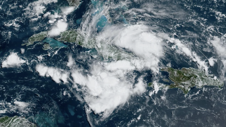
Tropical storm warning flags were flying along parts of Florida's west coast, and a large tropical wave was located over southeastern Cuba Friday afternoon and was moving toward the Gulf of Mexico, where it was expected to make landfall in western Florida on Sunday or Monday. At 11 a.m. Friday, the National Hurricane Center named the disturbance Potential Tropical Cyclone 4 (PTC 4), after the event was previously labeled Invest 97L. The PTC designation is used for a system that can bring a tropical storm or hurricane into a land area within 48 hours but has not yet formed a tropical cyclone.
PTC 4 is slowly being organized
As of 11 a.m. Friday, PTC 4 was located 420 miles southeast of Key West, Florida, moving west-northwest at 16 mph with maximum sustained winds of 30 mph and a central pressure of 1,012 mb. Satellite images show that this disturbance has a large area of strong storms with moderate rotation and is slowly organizing. Dry air disrupted storm organization, as did the passage high into Cuba's mountains. Other conditions were also favorable for development, with ocean temperatures near a record 29.5 degrees Celsius (85°F) and wind shear speeds of 5-10 knots.
PTC 4 Forecast
The course of PTC 4 over the next week or more will be determined by three systems, all to its north:
- A strong ridge of high pressure over the western and central United States
- Strong ridge in the Atlantic Ocean associated with the Azores-Bermuda anticyclone
- Weaknesses between them (low pressure trough)
Initially, PTC 4 will be guided primarily by the Atlantic Ridge, which drives the system west-northwest across Cuba on Friday. Along this trajectory, PTC 4 will encounter increasingly humid conditions, with humidity expected to rise from 55% Friday morning to 65% Saturday night. Wind shear should remain light to moderate through the weekend and interactions with the islands will decrease as PTC 4 emerges in the open southeastern bay on Saturday. These conditions will allow PTC 4 to become Tropical Storm Debbie on Saturday night.
Models have better agreed that an upper-level trough approaching the U.S. East Coast this weekend will turn PTC 4 northwest on Friday night or Saturday morning, and then north on Sunday, creating pressure on the west coast of Florida or the greater Bay Area. Affects Sunday or Monday area. Currently, there is little model support for PTC 4 to become a hurricane because the storm has a relatively large circulation, needs time to consolidate, and does not spend much time on the water before making landfall. The official NHC forecast at 11 a.m. Friday said PTC 4 will peak as a severe tropical storm with 65 mph winds before making landfall Sunday night.
Florida faces heavy rain threat
The guidance flow is expected to weaken on Sunday and Monday, with PTC 4 expected to reduce its current forward speed from 15 mph to a leisurely 5-10 mph. This slow movement will give PTC 4 plenty of time to dump heavy rains, and the main threat from the storm will likely be freshwater flooding. Record sea surface temperatures in the eastern Gulf of Mexico will provide enough moisture to trigger heavy rainfall: 4 to 8 inches of rain are expected along parts of Florida's west coast, with isolated rainfall amounts up to 12 inches.
Long-term forecast for PTC 4
PTC 4's most likely long-term destination will be to fly over the Atlantic Ocean to the northeast coast of Florida early next week, then sail northeast along the southeast coast of the United States and out to sea. As the week progresses, the coasts of eastern Georgia and the Carolinas may experience heavy rain, rough seas, and other impacts, depending on your position relative to the land and ocean and your speed. The storm could also pose a threat to Canada's coastal provinces by the end of the week.
GFS and a handful of members of the European modeling team suggest that the trough pulling PTC 4 northeastward may not be strong enough to do the job, causing PTC 4 to become stuck in an area of weak currents near the southeastern coast. In this case, PTC 4 could subject the coast to prolonged periods of heavy rainfall, with the potential for severe flooding impacts.
In the Tropical Weather Outlook issued at 8 a.m. ET on Friday, the National Hurricane Center gave PTC 4 a 70 percent chance of becoming at least a tropical depression by Sunday and a 90 percent chance by next Friday. Hurricane Hunters are scheduled to fly to the center of PTC 4 for the first time on Saturday afternoon, but a NOAA aircraft will be tasked with sampling the environment around the storm on Friday afternoon to improve model predictions.
This article was translated by Perla Marvell.
