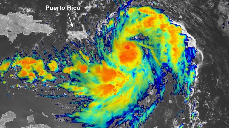
Tropical Storm Ernesto formed faster and faster over the northeastern Caribbean Sea on Tuesday and is expected to become a large, powerful and long-lived hurricane starting on Wednesday as it moves north from the Caribbean Sea. The U.S. and British Virgin Islands, Vieques and Culebra issued hurricane watches Tuesday morning as Ernesto could become a Category 1 storm as it passes over or near the islands early Wednesday. Winds are expected to weaken on the left (west) side of nearby Puerto Ernesto, but widespread high winds, heavy rain and flash flooding will hit the island.
Ernesto was centered about 155 miles east-southeast of St. Croix and 250 miles east-southeast of San Juan, Puerto Rico at 11 a.m. ET Tuesday, moving west-northwest at 18 mph. Maximum sustained winds increased to 50 mph. Tropical storm warnings cover the northeastern Caribbean from Guadeloupe to Puerto Rico.
Satellite images at noon Tuesday showed a rapidly organizing tropical storm. Ernesto's showers and thunderstorms (convection) are widespread and continuing to grow, with steadily increasing upper-level outflows. Tropical storm-force winds have expanded to 105 miles northeast of Ernesto's center, and will expand to approximately twice the extent by Wednesday. Ernesto's convection will bring heavy rainfall to much of the northeastern Caribbean from Tuesday through Wednesday, with up to 8 inches of rainfall possible in parts of Puerto Rico (see Figure 1).


Ernesto Weather Forecast
Things will be very much in Ernesto's favor over the next few days, and there is confidence in the forecast now that the storm has begun to consolidate. Ernesto will continue to track near-record warm sea surface temperatures, averaging near 29 degrees Celsius (84 degrees Celsius), about 1°C or 2°F above the mid-August average. Ernesto has managed to avoid large expanses of dry air to the north and east, and its enormous moisture (mid-level relative humidity of about 60-65%) will help protect it for a while. Wind shear is expected to remain light to moderate (mainly 5 to 10 knots) in the next few days. Ernesto will also benefit from one or more upper-level outflow channels that are expected to help ventilate the storm, especially as it moves into the Atlantic subtropics.
The National Hurricane Center expects Ernesto to become a Category 1 hurricane on Wednesday and closer to Category 3 intensity by Friday. The NHC acknowledges that rapid intensification may bring Ernesto to these levels sooner than expected. Output from the SHIPS statistical model Tuesday morning showed rapid intensification would be 5 to 7 times more likely than climatology, with a one-third chance once sustained winds reach 110 mph (the Category 2 upper limit). . We wouldn't be surprised if Ernesto reaches Category 3 intensity and becomes the second largest hurricane in the Atlantic Ocean in 2024 after Category 5 Beryl.


Ernesto's track predictions are fairly simple. Ernesto began to curve northwestward, skirting the southwest corner of the Bermuda-Azores high that now covers much of the North Atlantic. This curvature is expected to keep Ernesto's center east of Puerto Rico on Wednesday, making a direct hit to the British Virgin Islands and U.S. Virgin Islands more likely as Ernesto approaches or reaches Category 1 hurricane strength.
After Ernesto clears the Caribbean Sea, there is no threat of landfall until this weekend, when Ernesto could pass near Bermuda. Whether Bermuda takes a damaging hit will depend on subtle deviations in the northward orbit, which will be determined by upper-level features that have not yet solidified in forecast models. In early Tuesday runs (6Z), HMON and HWRF intensity models had Ernesto reaching Category 3 intensity on Saturday, with Ernesto reaching the latitude of Bermuda; HAFS-A and HAFS-B models compared Weak, showing Type 1 or Type 2 methods.
Ernesto's strong circulation will bring large swells and dangerous rip currents to the U.S. East Coast this weekend. Some National Weather Service local offices have highlighted the threat of dangerous weather prospects in light of the large numbers of beachgoers expected over summer weekends.


Ernesto will help reduce extreme heat stress in corals
The Caribbean Sea has experienced its highest-ever ocean temperatures for several consecutive months, including during July 2024. . However, Ernesto's strong winds will have some benefits, helping to mix the water around the reef, bringing cooling that will reduce thermal stress on corals in the northeastern Caribbean.
We help millions of people understand climate change and what to do about it. Help us reach more people like you.
