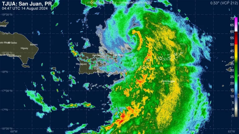
Hurricane Ernesto moved through the United States and the British Virgin Islands as a severe tropical storm late Tuesday night. It brought heavy rains and near-hurricane wind gusts to much of the Leeward Islands, Virgin Islands and eastern Puerto Rico. As storms intensify due to unusually warm waters, the likelihood of human-caused climate change increases more than 50 times, according to a tool released today by the nonprofit research group Climate Central.
Ernesto was classified as a Category 1 hurricane at 11 a.m. EST Wednesday with winds of 75 mph and a central pressure of 991 MB, becoming the third hurricane of the season after Beryl and Debbie . From 1991 to 2020, the average formation date of the third Atlantic hurricane was September 7.
Earlier Wednesday, the National Hurricane Center (NHC) reported that the WeatherFlow station in Culebra, Puerto Rico, recorded sustained winds of 68 mph (109.4 km/h) and gusts as high as 86 mph (138 km/h). . Naval Station Roosevelt Road in eastern Puerto Rico reported sustained winds of 48 mph (77.2 km/h) with gusts as high as 74 mph (119 km/h). A NOAA drone located about 65 miles northeast of San Juan, Puerto Rico, reported sustained winds of 61 mph (98 km/h) and gusts as high as 76 mph (122.3 km/h).
As of 10 a.m. EST Wednesday, 5 to 7 inches (12.7 to 17.8 centimeters) of rain had fallen over much of the Virgin Islands and 9 inches (22.8 centimeters) in eastern Puerto Rico. An additional 4 to 6 inches (10.16 to 15.24 cm) is expected in southeastern Puerto Rico.
At 11 a.m. Wednesday, Ernesto was about 175 miles (281.65 kilometers) northwest of San Juan, Puerto Rico, moving northwest at 16 mph (25.7 kph). A tropical storm warning covers Puerto Rico and the Virgin Islands. Satellite imagery shows an ongoing storm with widespread and growing showers and thunderstorms (convection). The dry air on the west side of the hurricane is injected by upper-level westerly winds, causing moderate wind shear of 10-20 knots, keeping the convection on this side weak.
Ernesto's Big Wave
Ernesto was a major storm with tropical storm winds extending up to 230 miles (370 kilometers) from the center and hurricane winds extending up to 35 miles (56 kilometers) from the center. By Friday, the National Hurricane Center forecast the hurricane-force wind field would expand, extending 115 miles (185 kilometers) from the center. This widespread wind field will produce large waves that will cause hazardous swimming conditions at beaches along much of the Atlantic coast of the United States and Canada later this week and early next week.
Ernesto's intensity prediction: possibly Category 2, possibly Category 3
Ernesto will continue to push near-record sea surface temperatures of about 29 degrees Celsius (84 degrees Fahrenheit), about 1 degree Celsius (1.8°F) above the mid-August average. According to Climate Central's Climate Change Ocean Temperature Tool, the record ocean temperatures Ernesto experienced as he approached the Leeward Islands were likely more than 50 times greater than human-caused climate change (Figure 2).
Wind shear is expected to be mostly moderate (10-20 knots) over the next few days. Ernesto will be in an environment with dry air, so shear may cause problems for the storm at times. The National Hurricane Center predicts Ernesto will peak on Friday as a lower Category 3 hurricane with winds of 115 mph before gradually weakening.


Ernesto's trajectory forecast: Bermuda and Newfoundland at risk
Ernesto will pass near Bermuda on Saturday and will likely receive at least tropical storm force winds from a major storm. Whether Bermuda is affected by Ernest's Eye's damaging effects will depend on subtle deviations in its northward orbit, which will be determined by higher-level features that have not yet solidified in forecast models.
A trough of low pressure moving north of Ernesto is expected to turn the hurricane further northeast early next week, with the storm potentially threatening eastern Nova Scotia and Newfoundland, Canada.
This article was translated by Perla Marvell.
