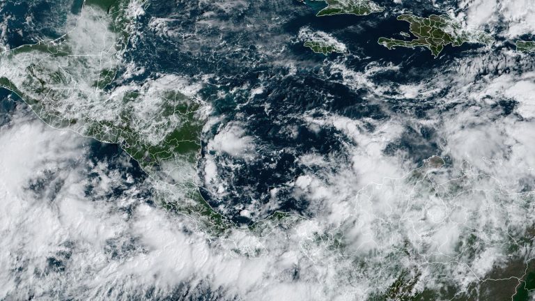
It's November, the last month of the Atlantic hurricane season, and the active 2024 hurricane season appears to be about to kick off a November storm named “Patty” in the western Caribbean. A large low-pressure system known as the Central American Gyre (CAG) is developing over Central America and the southwestern Caribbean, which will bring heavy rain to parts of Central America. Panama and Costa Rica could receive more than 10 inches (250 millimeters) of rain in the coming week, potentially causing dangerous flash floods and mudslides. The circulation also has the potential to generate tropical storms.


A gyre is a type of monsoon depression, a weak but broad area of surface low pressure that can persist for two weeks or more over Central America and adjacent areas of the Atlantic and Pacific Oceans, including the western Caribbean and southwestern Gulf of Mexico. They are most common in May, June, September, October and November. Circulations often produce smaller circulations that may become full-fledged tropical cyclones, which may be strong or weak in intensity. One such circulation formed in the Gulf of Mexico in June and became the first named storm of the season, Alberto. What's more serious is that this year's two catastrophic hurricanes in the Gulf of Mexico, Helen and Milton, were both triggered by CAG.


The Central American gyre typically takes many days to form, and once fully formed, it takes several more days to produce a tropical cyclone. The location of a tropical cyclone spawned by the Central American Gyre is difficult to predict more than two days in advance, but our top forecast models have been predicting it will spawn sometime during the Atlantic's next named storm, Patty. . Conditions in the area were generally favorable for development, with wind shear of 10-20 knots, a moist atmosphere and sea surface temperatures near 29°C (84°F), about 0.5-1.0°C above average.
A strong ridge of high pressure over the northern Caribbean Sea will allow the developing system to slowly drift northward, potentially bringing heavy rain to Jamaica, the Cayman Islands, Cuba and Haiti in the coming days. The system will likely turn northwest by Tuesday, which could move into the Gulf of Mexico by midweek.


The harsh environment of the Gulf of Mexico
If the “Wannabe Patty” eventually succeeds in making its way into the Gulf of Mexico, the environment will be less favorable than the conditions experienced by hurricanes Helen and Milton in September and October. In recent weeks, recurring fall cold fronts have spread cold air over the bay, causing the water to cool significantly. More importantly, the jet stream will shift more southward, which will bring high wind shear and accompanied by dry air, making it difficult for the Gulf tropical cyclone to strengthen (Figure 3).
In its Tropical Weather Outlook, released at 8 a.m. ET Friday, the National Hurricane Center gave a two-day and seven-day probability of tropical cyclone development in the western Caribbean at 30 percent and 70 percent, respectively. As of Thursday, no Hurricane Hunter missions had been scheduled for the system.
Bob Henson contributed to this article.
