From Cliff Mass Weather Blog
cliff mass
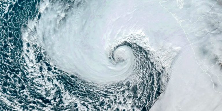
The latest satellite images show the offshore storm is developing rapidly.
The visible satellite image around 9am is stunning, with low-level clouds swirling around the low center (orange arrow points to the low center).
Amazing.

This is an explosion of clouds around the low center. The cycle is obvious.

Strong, fast-developing storms have not only an upward motion that produces clouds, but also a strong sinking motion that creates a “trough” of dry air blowing from the southeast.
We can look at the “dry trough” using satellite images that reveal the amount of water vapor in the upper and middle troposphere. As shown in the image below, blue indicates very dry air. This is a strong storm…no doubt about it.

The latest National Weather Service surface map (I do have some questions about the quality of their analysis) shows the storm at 7 AM with an analyzed minimum surface pressure of 974 hPa. The storm is rapidly deepening today so pressure will drop significantly.

As I mentioned in a previous blog, while strong coastal winds are a concern, my biggest concern is the strong winds east of Puget Sound tonight.
The models are still good for threatening winds…there is an obvious threat of severe tree damage and power outages.
The European Center's latest forecast calls for winds in excess of 70 mph on the east side of Puget Sound, especially toward the western Cascade foothills. These are easterly and southeasterly winds…not the usual direction for strong local winds.

The NOAA/NWS HRRR model, run at high resolution, is similar but extends the strong winds over Whidbey Island and the San Juan Islands.

The east side of the University of Washington model is also facing the threat of strong winds, with gusts reaching 50 knots (about 57 mph) at 10 p.m.

According to dozens of forecasts, maximum wind speeds over Seattle are expected to reach 45-60 mph… coming from the east (see below).

Bottom line: Strong winds from the east, with gusts to 40-70 mph, will occur east of Puget Sound and become stronger toward the Cascade Islands. Severe damage to vegetation and multiple power outages are expected. If you live in one of the vulnerable areas mentioned above, it's probably not a good idea to drive along wooded streets after 6 to 7 p.m.
____________________________________________
appendix:
Here's the satellite image at 1pm…the circulation is becoming very, very apparent.

Some satellites can measure low-level winds by measuring wave action… called a scatterometer. Below are surface winds measured by scatterometers around the storm around 12:30 PM PST. Strong circulation around the low pressure area is evident.


Relevant
