BALTIMORE — Baltimore experienced its third consecutive day of record-breaking heat on Tuesday.
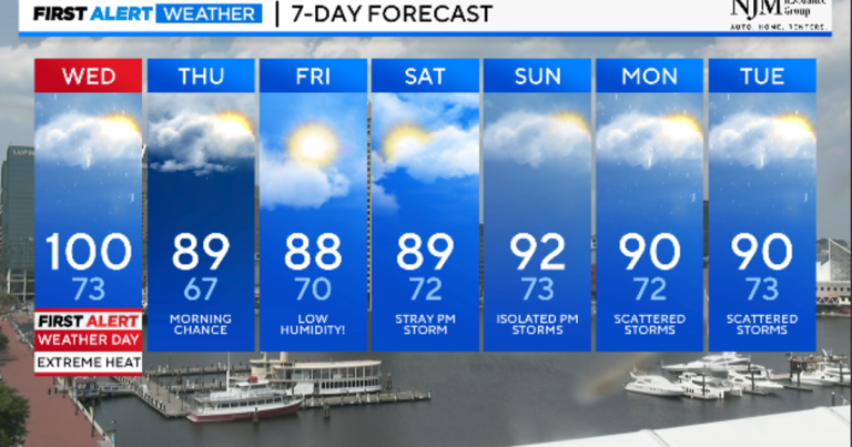
Temperatures could reach triple digits on Wednesday.
Maryland has issued excessive heat warnings and heat warnings, with the heat index reaching 110 degrees tonight. Additional heat advisories and warnings may be issued Wednesday.
Maryland is experiencing an extremely dangerous heat wave if you don't take the proper precautions to stay cool. Please continue to take all heatstroke prevention measures, including drinking plenty of fluids, taking breaks with the air conditioner on, staying out of direct sunlight, and checking in on pets and the elderly.
BWI Thurgood Marshall Airport recorded a high temperature of 104° on Tuesday afternoon, tying the all-time high of 104° set in 1988.
Scattered to scattered severe thunderstorms are possible until 11 p.m. These storms are few and far between, but any that form can cause straight-line winds, dangerous cloud-to-ground lightning and brief downpours.
Overnight lows will generally be in the upper 70s to lower 80s.
A strong cold front will approach the area on Wednesday. Ahead of this front, high temperatures will soar to nearly 100°. It feels like temperatures will once again reach peaks in the mid to upper 100s. Ahead of the cold front, strong to severe thunderstorms will develop, bringing damaging winds, intense downpours and lightning to the area. In addition to Wednesday's extreme heat warning day, we need to remain alert for the potential for widespread severe weather.
Following Thursday's front, we will see a remaining set of showers or thunderstorms, especially Thursday morning. Highs will peak in the 80s.
Humidity dropped significantly on Friday. This is going to be the best weather of the week! Highs will top out in the early 80s with plenty of sunshine.
Humidity will surge across the region this weekend, with isolated to widespread thunderstorms possible in the afternoon. Right now, the best chance for a storm appears to be Sunday afternoon. High temperatures this weekend will be in the upper 80s to lower 90s.
