Track tropical and local storms tonight
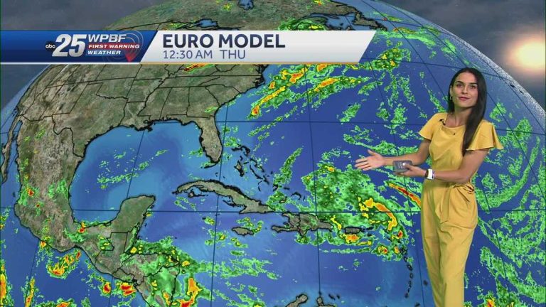
Early 1980s. Then look for 70s style throughout the night. Wake up tomorrow morning to temperatures in the 70s on the Treasure Coast and 70s in Palm Beach, and then another round of storms is expected to bring the tropics. There is nothing to develop in the Gulf of Mexico or Caribbean Sea, just to the east of the Caribbean Islands. We have very unsettled weather in our area right now. It doesn't look very organized. Remember, there is a lot of dry air around us. We still have Saharan dust, so it will be very interesting to watch this system as it may develop further over the next few days as it continues to move westward. But right now, for us in Florida, there's still a lot of uncertainty about what the final outcome will be, but we're looking for those model trends. We look for consistency, we look for difference. Now we're going to look at the GFS model together. Tropical moisture remains very chaotic Wednesday into Thursday morning as it moves westward closer to the islands. Again very confusing. If it does stay disorganized and very weak, then it has a better chance of turning west and into the Gulf of Mexico because we have high pressure. This is the Greater Bermuda high pressure area, and there's another high pressure area there. This keeps the steering in that motion. The other model we're looking at is the European model, which is a little more organized. If this does become a stronger system, it will cause it to turn eastward faster, away from the continental United States. If it does stick around, perhaps as a weaker tropical storm, it could also move west along this path. So we're going to be monitoring closely for you right now in South Florida again. No progress is expected over the next few days. But as the work week comes to an end next weekend, we could be in for the next storm. The next name on the list is Debbie. We already had a Category 5 hurricane earlier this season, and that was Beryl. Tonight, 70s, low 70s, showers expected tomorrow. Affects rainfall and storms. We will see broader coverage later in the afternoon, particularly in Palm Beach County. We spent the night cleaning things up. Stay good Monday morning and Monday afternoon. Rain and storms began as early as 2:00. The action then continued throughout the night. So we're going to be dealing with scattered rain, heavy downpours, and the potential for street flooding on some ground that's already pretty saturated. That’s your Monday snapshot. Beach and boating conditions tomorrow. Look for a feel like cutting inshore waters at a depth of around 1 to 2 feet. Otherwise, the wind speed is quite light from the southeast at about 5 to 10 knots. Lows Monday and Tuesday will be in the mid 90s. The weather will be affected on Wednesday and Thursday as temperatures will reach record highs around 96 degrees with limited rainfall. Of course we will continue to monitor the tropical conditions there for you, but at the moment, there is no tropical impact over the next few days
Scattered storms and high temperatures are expected on Monday. Temperatures will reach the mid-90s. Temperatures are likely to reach record heat by midweek. We will be monitoring unrest in the Mid-Atlantic. There is too much uncertainty about the ultimate direction of this system.
Scattered storms and high temperatures are expected on Monday. Temperatures will reach the mid-90s. Temperatures are likely to reach record heat by midweek. We will be monitoring unrest in the Mid-Atlantic. There is too much uncertainty about the ultimate direction of this system.

